[ad_1]
Outlook for fall weather, and how much snow Ohio could see
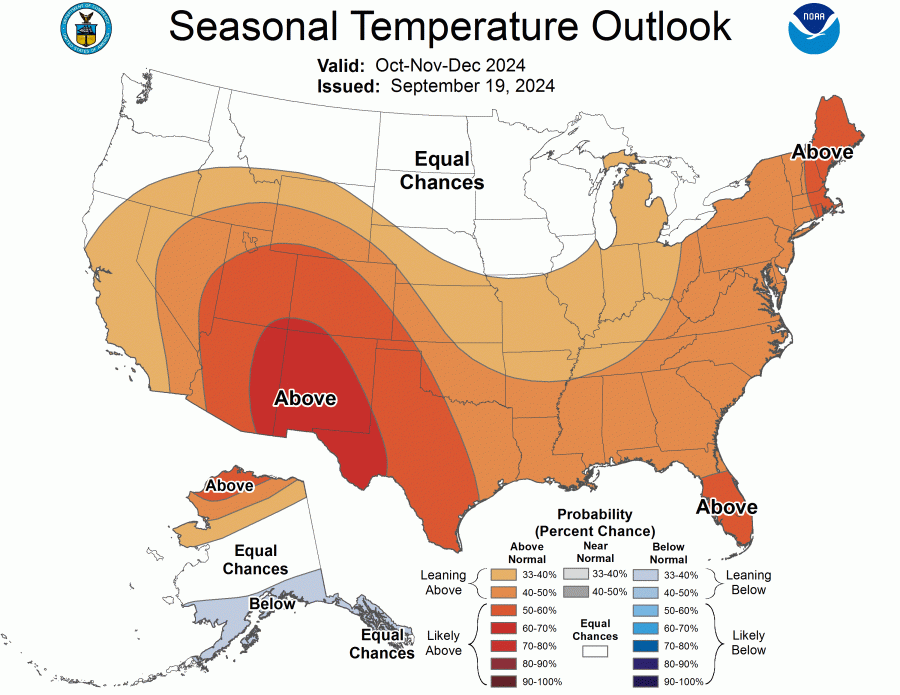
COLUMBUS, Ohio (WCMH) — NOAA’s Climate Prediction Center is forecasting milder-than-normal weather through the fall, with slightly above-normal rainfall across Ohio.
Average temperature forecast October-November 2024. (NOAA)
The forecast for precipitation leans toward wetter-than-normal conditions around the Great Lakes and Northeast, extending south across northern Ohio and Pennsylvania.
Average precipitation forecast October-November 2024. (NOAA)
The four-month drought affecting much of Ohio was partially relieved by rain from the remnants of Hurricane Helene that curled northwest into Kentucky and stalled for several days, although extreme-exceptional drought conditions persist over a large portion of eastern Ohio.
U.S. Drought Monitor issued Oct. 3, 2024. (NOAA/USDA)
The search for signs of what to expect this winter regarding snowfall usually focuses on Pacific climate patterns, one of several factors that influence the average storm track across the continental U.S. in the winter.
There is a 71% chance for La Niña to develop and linger through much of the upcoming winter. La Niña reflects a cooling of the equatorial eastern and central Pacific Ocean, the opposite of El Niño that prevailed during the winter of 2023-24 in North America.
The usual tendency reflected in the jet stream (storm track) is a northward shift of the heaviest precipitation during La Niña.
Looking at weaker autumn La Niña patterns since 2000 and the average winter temperature (32.2 degrees) and snowfall (28.2 inches) in Columbus that followed offers a clue regarding the nature of the winter to come.
Five of the six winters were less snowy compared with the 30-year average (1991-2020), while temperatures were above normal in half of the winters.
Weak La Niña Winters
WINTER
SNOWFALL (Oct.-May)
AVERAGE TEMPERATURE (Dec.-Feb.)
2000-01
26.3
29.1
2005-06
12.9
34.7
2008-09
23.2
29.9
2016-17
17.1
31.6
2017-18
29.8
32.4
2022-23
12.5
37.7
However, half of the Januarys featured below-normal temperatures, indicating a southward shift of the jet stream often brings several weeks of true winter weather in a La Niña pattern.
Interestingly, in six moderate La Niña seasons since 1950 (cooler water than in a “weak” pattern), half of the winters were fairly cold and snowy.
There are several other key variables such as solar activity, which is approaching a maximum this winter, snow cover in northeastern Asia and northern Canada, and Atlantic sea surface temperature patterns that affect the nature of winter, which are unknown this early in the fall.
Copyright 2024 Nexstar Media, Inc. All rights reserved. This material may not be published, broadcast, rewritten, or redistributed.
For the latest news, weather, sports, and streaming video, head to NBC4 WCMH-TV.
[ad_2]
Source link
#Outlook #fall #weather #snow #Ohio


